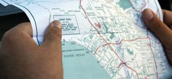
GPS is one of the miracles of the information age. In 25 years it’s gone from being an expensive technology mostly used by the military and oil companies, to so cheap and ubiquitous that almost every cell phone now doubles as a navigation device. This is great for getting around, but unfortunately it also means we’re slowly forgetting about a much more reliable navigation aid – maps.
Maps take some skill to use properly, but unlike a GPS they don’t need batteries. They won’t stop working if some mad dictator hits us with an EMP attack, the military decides to scramble the signal for unencrypted (i.e. all non-military) receivers, or you just drop it on pavement. They’re robust, low-tech and, in a crisis, invaluable. If you want to be prepared, and your plans involve anything more than sitting quietly at home, you need to have maps.
This goes double if you plan to bug out in a crisis. Sure, you probably have the route from home to your BOL memorized, but what if you can’t follow that route? Maybe an earthquake has brought a key bridge down, or the town you planned to drive through is sealed off by the National Guard. That’s when you need to be able to reach for a map and find another way.
Not all maps are created equal, though. Just go to Amazon – or even your local book store – and take a look in the map section. There’s a bewildering range of them out there, and you can’t carry them all. To help you narrow the choices a bit, here are the essential maps you should have in your bug-out bag.
USA Road Atlas
You probably won’t be planning any road trips after the SHTF, but having access to maps of the whole country is still useful. If you’re in radio contact with other preppers – especially if you have a long-range ham set – it’s helpful if you can see the places they’re talking about on a map. And, although you might not be planning on going anywhere, you might find that circumstances force your hand.
Imagine your area is threatened by a disease epidemic, or contamination from a nuclear accident. You can stick to your bug-in plan as the fallout comes down, or you can get out of there and survive – but if you’re going somewhere, you need to know what roads will get you there safely and what ones lead into potential danger areas.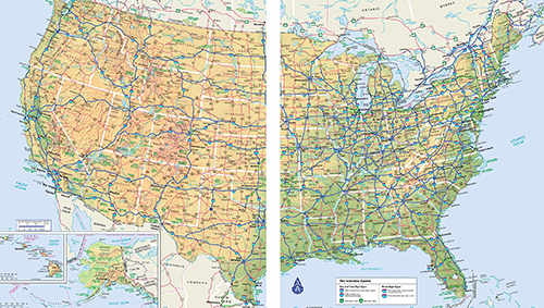 A road atlas isn’t any good for fine detail, but it will tell you enough to let you plan your general route. With any luck you can pick up more detailed local maps as you go. A road atlas will also show you service areas and gas stations, where you can buy (or scrounge, if they’re abandoned) valuable resources.
You can find a North American road atlas, with maps of every state and Canadian province, on Amazon for just over $8.
State Road Maps
Aim to have a good road map for your own state. This will be at a larger scale than a US road atlas, so it should show minor routes that don’t appear in the atlas. Minor routes get less traffic, making them great options for a discreet bug-out.
The more routes you know of, the better your chances of making it to your BOL whatever challenges you meet along the way. If there are refugees moving around they probably won’t know the minor routes, but they’re more likely to know the major ones. In fact, a good rule, where you have both maps available, is to avoid routes that appear on both and stick to ones that only show on a state (or even local) map.
Rand McNally do a great series of “Easy to Fold” state road maps. These cost $8 or less per state on Amazon, and the maps are laminated with weatherproof plastic. That lets you write on them with markers (but don’t mark any sensitive locations, like your BOL or home), and it also means they shrug off rain and snow.
Related: How To Cleverly Use A GPS Tracker
Street Maps
If you live in a city or suburb, you need good street maps of the surrounding area. This is something a lot of people overlook. After all, this is your neighborhood. It’s where you live. Surely you know your way around it without a map?
Well, actually you probably don’t. Most urban people know the routes that will take them where they need to go regularly, but beyond that their knowledge can get a little hazy. Go on Google Maps and look at your area. Do the streets relate to each other the way you thought they did? Probably not. You’ll also likely see other ways of getting places that you didn’t know about, because you never needed to. 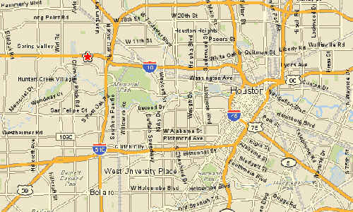 The thing is, in a crisis you might find that you do need another way of getting somewhere – like out of town, for example. If you plan to bug out, but the road you usually take out of town is closed by a fire or a riot, what are you going to do? Driving around randomly looking for an alternative route wastes time and fuel, and risks driving into trouble. A good street map will let you back off, look for another way out, then navigate along it.
We’re all used to finding street maps online, usually through our phones, but in a crisis you can’t rely on that. You need paper maps. If your city has a tourist information office, look there – they usually have cheap, or even free, maps for visitors. Anytime you visit another city and see an information office, see if you can get maps for there too. You never know when they might be useful.
Fish And Game Maps
Your state fish and game agency probably have a range of maps available, either to buy or download and print. A lot of these are very useful resources for preppers. For example, you can easily find places to fish, but a fish survey map will show you where the fish actually are.
Wildlife management maps do the same for deer and other game species. If you need to hunt en route or at your destination you can find some woods and hope for the best, or you can check the map and locate a good spot. Fish and game officers have done the work of finding out where the food is, so use that information to help you.
Related: 16 Items FEMA Tells You to Stockpile and Why
Regional Topographic Maps
The maps we’ve covered so far are specialized ones, and they all have their uses. You also need good general-purpose maps, though, and the best ones available in this country are the US Geographical Survey’s topographic maps. Unfortunately, that’s not saying a lot. If you’ve ever seen a 1:50,000 Ordnance Survey map from the UK, you’re going to be pretty disappointed with the USGS ones. They’re good enough though, and they do contain a lot of information.
A topographic map shows you urban areas, roads, water and terrain contours. If you know how to read contour lines (and if you don’t, learn in a hurry!) you can use a topographic map to plan routes, choose campsites and even work out the limits of visibility from a location.
The USGS has several series of maps covering the USA. The best quality, and most detailed, ones are the 1:24,000 “7.5 minute” series. These don’t cover a large area, so you might need a lot of sheets, but they have the most information. Just be aware that in the last couple of decades updates have been sparse, and accuracy has suffered.
You can also get smaller-scale, but more manageable, 1:100,000 topographic maps. These don’t have as much detail, but each sheet covers a much larger area. A good plan is to get all the sheets for both series that cover the route between home and your BOL.
That way you have detailed information for your planned trip, but if you have to detour you’ll at least have slightly less detailed maps that cover more ground and give you some room to maneuver. Whatever scale of maps you get, make sure you have a matching romer to help you read and plot grid references.
USGS maps can be bought in most large bookstores or from Amazon. You can also go to the USGS website and either download and print them free (although this will use a lot of ink and A4 paper) or you can order them from USGS, with lamination as an optional extra.
You may also like:
 A Medicinal Plant MAP That Should Be in Your Survival Kit
10 Things Cowboys Carried With Them in the Wild West to Survive (Video)


If you have maps from 10 years ago or a little more, keep them. I have found that the newer automobile club maps are getting sparser on detail. So many folks use GPS for navigating these days that the auto club folks have decided to go economy, at least in SoCal. The most recent map I picked up for Kally only shows the freeways. It has none of the detail that my older maps have. Well, duh, if you need a map to drive to Las Vegas or SF, your mommy shouldn’t let you out of the house by yourself. So before you pop for a “brand new” map make sure it shows the detail you will need for a bug out. A map that only shows the major highways is only good for sanitary purposes.
Now if there has been a lot of road building in the last ten years, of course, you need to check to make sure the new roads are on the map. No worry about that here in the state that is regressing. We don’t maintain the roads we have let alone building new ones. The only new road building has been for toll roads so the rich don’t have to spend time in traffic like the hoi polloi.
Sadly the USGS topographic maps are getting less detailed, too, so the same advice applies – hang on to old ones. They might not show the new roads, but they’re likely to be a lot better at terrain detail.
I used to work for the Defense Mapping Agency. Pay attention to the published date. When I was working there we would get maps that were 20 and 30 years old from the USGS. I would also suggest looking to local governments because many of them will have GIS shops and they are likely to be more up do date and more accurate.
hop,
I was a geodetic surveyor for DMA/HTC in the 80’s and was in the initial tests for GPS. Too much technology dependence for me. Still have a state map and atlas in each vehicle.
I also have a Gazeteer atlas for my home state…lots of details, including mines and wells…
I absolutely agree. You bug out shouldn’t have to be cross country. The gazeteer has all the unimproved roads you can use to move “behind the scenes”.
Crap I learned something new today it will take a day or two for the headache to subside.
Have always used maos.GPS is fine, but I use the Rand-Mcnalleys to navigate. The batteries and service never go down on a hard copy printed piece.A good compass should accompany it!
Amen.
Roger that!!!
Indeed…a must. Never leave home without these. Thank you for reminding us!
What compass do you recommend?
Most US States give away free maps off their websites or by calling their toll-free #s .. also at their Information/Rest-Stops. .. many cities & towns offer few maps through the Chamber of Commerce .. also the Park Systems offer maps @most points of entry ..
You wont accept passworb or e mail so forget it…..
This year we found the most amazing custom map service and ordered two HUGE 2’x3′ laminated maps for our living room walls. Unlike the USGS maps that show us on two different maps (why do we always seem to end up on the seams?!) we were able to center our property right in the middle of the customized maps. The first satellite map shows the property lines and names of almost a hundred of our neighbors, while the second is a detailed topo showing our position/elevation in relation to the hills, ridges, hollows, creeks, ponds, forests, pastures, and other geo features for miles immediately around us. Each map cost around $50 but they’re pure gold to us, quite beautiful and enormously useful on an almost daily basis (we’re not just preppers but also gardeners and permaculturists with significant forests, therefore a real need to understand the watersheds / flood zones / drought problem areas that directly affect us and our livestock).
Anyone can order the same kind of customized maps of their own property and surrounding areas by typing their location into http://www.mytopo.com/search.cfm — HOWEVER, some advice: play with all the different available options when you identify your exact location before ordering. It took me a week to get the precise view I wanted, finally settling on lat/long tick marks instead of lines on the topo map only… it really comes down to personal preference after fiddling around, so be careful not to be too quick on pressing the “buy” button.
Chris: Thanks for the useful information and the helpful link. As soon as I post this I am going to that site to look at what they have.
I have used My Topo and was very happy. I printed my maps directly from my computer.
Another good source for maps is AAA. If you are a member just go into any AAA store and ask for a map of any state, city, town and they will GIVE it to you. Something is better then Nothing!.
True, however, note my caution above. This only applies to SoCal as I don’t know what auto clubs in other regions are doing. I have this experience with the SoCal Auto Club.
If you have AAA, the paper maps for the U.S. , citys and states are free. There are also regional maps that are free. To get them just order from their website. Easy. I keep a set in all of the vehicles and BOBs. Also a Gazateer map of your state is invaluable. It has topo and roads that are not state maintained like fire and logging roads.
Water Pro: After reading your post, I went on line to AAA of SoCal. If they have a place for ordering maps on line, they have very cleverly hidden it from the casual peruser of their website. Perhaps auto clubs in other locales make maps available to members on line but the SoCal auto club apparently does not. One can obtain maps by going to the local office and asking for them but they don’t maintain a list of maps that are available. Also, sometimes they are temporarily out of the map that you want.
I am willing to be corrected if someone can post the link to the SoCal Auto Club membership map ordering feature.
Collecting maps has always been kind of a obsession with me. Unfortunately, recently, at the behest of my heirs who do not want the task of sorting through my collections, I culled many of my maps only to discover the newer ones didn’t contain the detail that the older ones had.
Left coast Chuck, different subject but I enjoyed your post on using bicycles. Gave me a reason to pull 2 down from the barn rafters for service.
Further update, go to AAA midatlantic site. The map ordering ( printed maps) is in the get directions section. I ordered maps 5 days ago and UPS delivered them today.
Finally something that isn’t a repackaged post from a few months ago
Great job
Thank you so much for this valuable info. I have become to reliant on my phone.
Good news! All of the US topographic maps, both current and (the superior) historical ones have been digitized. See https://ngmdb.usgs.gov/topoview/
You can download them as PDFs and then print whatever sections you want. To print larger than 8.5×11 paper, office supply / print shops can do it for you.
Did I mention they are free?
Pick up some sectional maps at your local airport as these not only show topo features but land marks as well.