For many people, off-grid living has always carried a certain promise. The promise is not only about producing your own power or collecting your own water, but also about stepping away from the crowds. When someone imagines building a cabin far from the city, it is easy to believe that distance alone creates privacy and that the further you go, the harder it becomes for anyone to find you.
However, that belief is starting to break down. Modern mapping is now tied to national security, emergency response, military planning, and advanced surveillance systems that do not require anyone to ever set foot near your property. This is where the uncomfortable reality begins, because off-grid does not always mean invisible anymore.
Off-Grid Living Is Not As Hidden As It Used To Be
Years ago, living off-grid often meant living outside of view. Remote areas were harder to access, fewer records existed, and the sheer emptiness of the landscape created natural privacy. Today, that privacy is much thinner, even in places that feel untouched.
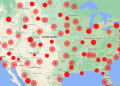
Satellite imagery has become sharper, more frequent, and automated. Remote valleys, forest clearings, and desert structures can be seen from above with surprising detail. Even if a location is not well known locally, it can still appear in databases that track terrain, buildings, roads, and changes in the environment. This means that the idea of being “off the map” is becoming less realistic, even for people who truly live far from modern infrastructure.
Why Would the Pentagon Care About Remote Locations?
 At first, the idea sounds strange. Most off-grid homesteaders are not doing anything illegal, and they are not threats to anyone. So why would the Pentagon be involved at all?
The answer is that the Pentagon does not think in terms of personal lifestyle choices, but they see it as strategic awareness. Military agencies monitor geographic information because terrain matters during emergencies and conflicts.
And in recent years, this strategic awareness has gone far beyond satellites and aircraft. The Pentagon has openly tested high-altitude surveillance balloons over parts of the United States, floating at the edge of the stratosphere and quietly watching entire regions at once.
These systems were designed to track movement patterns, vehicles, and activity across hundreds of miles, proving that wide-area monitoring no longer depends on drones, planes, or boots on the ground.
Certain areas are considered sensitive, and certain types of infrastructure, even private infrastructure, can become part of larger mapping concerns. In some cases, locations are removed or blurred from public-facing maps because they are too close to training sites, critical facilities, or restricted zones. The goal is not always about targeting individuals, but about controlling what is visible to the public and what is not.
For anyone living remotely, the disturbing takeaway is simple: distance no longer protects you when observation can come from directly above, day after day, without anyone knowing it’s there.
When Emergency Mapping Turns Your Private Land Into Government Data
One of the least discussed reasons remote locations attract government attention is emergency planning. Wildfires, floods, earthquakes, and severe storms force agencies to map every structure they can find, especially in hard-to-reach areas. When disasters happen, responders cannot afford guesswork, so they rely on satellite scans, terrain models, and updated structure databases to understand what exists on the ground.
Is Your House a Burglar Magnet?
There are real cases where off-grid cabins were discovered and cataloged during wildfire mapping operations in the western United States. These structures were not targeted, but once identified, they were added to emergency response systems. That information did not disappear after the fires ended. It became part of a permanent geographic record used by multiple agencies.
If you are an off-grid homeowner, this matters because emergency mapping does not ask for permission. If your cabin exists, it can be logged. If it is logged, it can be shared. Over time, a location that once felt unknown becomes a data point inside systems designed for national-scale planning.
Military Training Zones Are Expanding Into Remote Areas

Another reason the Pentagon tracks remote locations is that military training increasingly takes place far from cities. Large stretches of rural land are used for flight exercises, navigation drills, and terrain simulations.
These areas often overlap with regions favored by off-grid homesteaders because they are sparsely populated and difficult to access.
A real-world example that raised public awareness of this issue was the 2015 military exercise known as Jade Helm 15.
The training operation took place across several southwestern states, including Texas, Arizona, and New Mexico, and it involved special operations forces conducting realistic drills over wide rural regions. Although the exercise was officially described as preparation for overseas deployments, many residents were surprised to learn how much military activity could occur so close to remote private land.
When areas become part of military planning, even temporarily, they often receive more attention from surveillance systems, aviation safety databases, and geographic monitoring tools.
In several documented cases, landowners discovered that their property was close to newly designated training corridors or restricted airspace. While their homes were not seized, public map visibility around those zones changed. Some structures were removed from consumer map platforms, while others were flagged internally for operational awareness.
This creates a strange situation where an off-grid location may still physically exist but becomes less visible to the public. The decision is strategic. When military planning shifts, the map shifts with it, and private land can be affected without warning.
To understand how the military think when they participate in such experiments, you should check out these SEAL-Tested survival skills that will hep you survive the next crisis. For example, you will find out how to avoid deadly bug-in mistakes, what will become extremely valuable after an EMP, and where to find shelter in the event of a nuclear strike… And this is not even half of it. Find out more here.
Technology Finds Patterns Humans Used to Miss
Perhaps the most unsettling change is how pattern detection works today. In the past, someone had to notice a cabin or road manually. Now software does the noticing. Algorithms compare satellite images over time and highlight changes that stand out from the surrounding terrain.
For example, a clearing in a forest that slowly expands, a new access path that cuts across undeveloped land, or a roof that reflects heat differently than natural surroundings can all trigger automated attention. These systems were designed for defense and intelligence purposes, but they also capture civilian activity by default.
There are real-world examples of remote properties being flagged simply because they appeared unusual compared to nearby land. No crime was involved, but the locations were reviewed, logged, and stored for reference. This shows how off-grid life can unintentionally draw attention, even when the goal is privacy.
Off-Grid Privacy Is Becoming Harder to Maintain
Many people choose off-grid life because they want control. They want fewer systems involved in their daily survival. They want independence. Yet privacy is now tied to technologies that most individuals cannot opt out of.
Mapping systems are constantly updated. Drones are increasingly common in disaster assessment. Government agencies share geographic data with one another for planning purposes. Even public map services often rely on the same underlying satellite sources used by defense and intelligence organizations.
This creates a future where the blank spaces on the map are shrinking. The world is being documented more completely each year, and remote living no longer guarantees obscurity.
The Real Issue Is Visibility, Not Presence
 One of the biggest misconceptions about modern surveillance is that someone has to physically visit a place for it to be known. That is no longer true. Visibility today is often created digitally.
A structure that appears in satellite imagery can be flagged automatically. A new road cut through the trees can show up as a change in terrain.
Even something as simple as a cleared patch of land can draw attention because algorithms are designed to detect unusual developments in remote regions.
This is what makes the situation unsettling for people who believe distance equals privacy. You may never see a government vehicle near your property, but that does not mean your location is unknown.
What This Means for You
If you take privacy seriously, the biggest mistake you can make is assuming that remoteness automatically equals safety. The world has changed, and locations that feel hidden on the ground can still be visible through mapping systems, emergency databases, and long-term surveillance tools. This does not mean off-grid living is pointless, but it does mean you need to think in terms of reducing attention rather than expecting total invisibility.
There are a few practical steps that can help keep your home from standing out unnecessarily.
- Avoid large clearings and obvious land changes, because those show up clearly in satellite history.
- Keep access routes subtle, using existing trails instead of cutting straight new paths.
- Build in ways that blend with the terrain, so your structure looks natural rather than isolated and exposed.
- Limit highly reflective surfaces, including oversized solar arrays that can be spotted easily from above.
- Reduce unnecessary digital connections, such as deliveries, registrations, or services tied directly to your location.
- Be cautious with constant lighting or strong signals, since these confirm ongoing activity even in remote areas.
- Know what surrounds you, especially military training corridors, restricted airspace, and emergency mapping zones.
But even these methods only go so far. They help in the short term, yet there is one step you must take if you truly want to protect your property and your privacy. It is completely legal, but it may feel controversial, because it runs against the habits and assumptions most people never question.
This is the best way to completely stay off the Government’s radar:

Here’s the detail most people don’t realize until it’s too late.
Once your property shows up in a database or satellite record, it never truly disappears again. From that point on, privacy depends less on distance and more on how much you still rely on the outside world.
In a long emergency, the fastest way to become exposed is having to leave home for food, supplies, or basic survival.
Autopilot Homestead is built around the simplest way to remove that dependency, by showing you how to grow your own groceries, preserve what you produce, and build a long-term stockpile that doesn’t rely on stores or supply chains.
If you want a food system that keeps you steady when everything else becomes uncertain, you can start here:
Final Thoughts
The most important question is not whether the Pentagon is personally interested in your cabin. The real question is what happens when governments and large systems decide which places stay visible, which places get blurred, and which places become part of a bigger security picture.
Off-grid living is still possible, and it is still a powerful form of independence. However, the world has changed, and the map is no longer just a map. It is a living system of surveillance, data, and control that continues to grow.
If you want to live off-grid today, you should still build, prepare, and protect your family, but you should do it with open eyes. The wilderness may still give you space, but it does not guarantee secrecy anymore.
You may also like:
 7 “Safe” US States That Might Soon Be a Target
UN Warns That a Super Famine Is Coming in the Next Few Years (VIDEO)


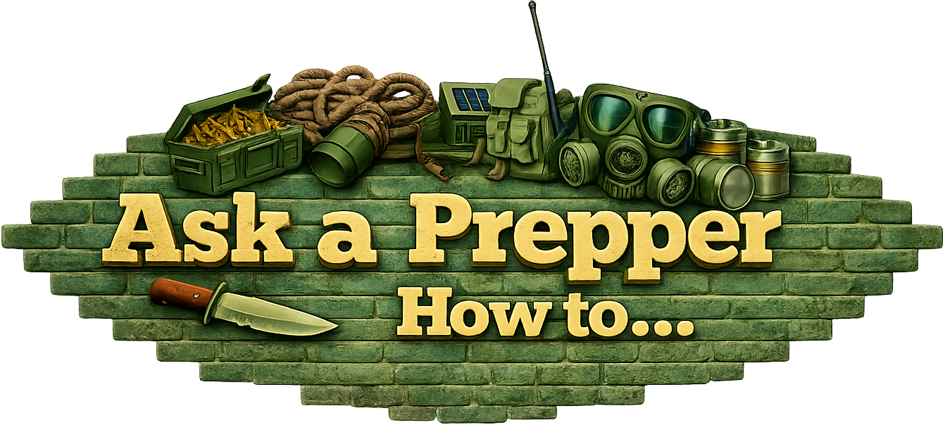
I am not in a position to say what may become of the information, but I can verify that the data is being collected. I live in (a small ) town but have property out in the country. Both Google Earth and the county property portal show a lot of detail. At my home I can pretty well date the photos by the position of shade clothes that change slightly from year to year. At the farm a pallet or two of stored materials give it away. Note that they stored for later use, a dump site would be illegal. I can count prairie dog mounds in the pasture so there’s not much you can hide.
You can contact google and have your property removed/blurred out so it can not be visually identified.
pay attention : all the kings men and all the kings horses are being put in place for the Total control System
Nowhere to hide , Nowhere to go
you will not buy or sell with out the mark of the beast
It is already in place
as the bible says Kings with out kingdoms for the 10 nation alliance
Imaging can see heat signatures up to 100′ into the earth from space
next phase in the system of control
you will own nothing and be happy
Slavery will be in place for the end
marked or starved , marked or collected for prison camps
You must read , study , seek out truth while you can .
If you legally own any property in the U.S.A….sorry , but you have to pay property taxes Or the county will take it and put it up for auction for the amount of taxes owed. Pending on your state’s laws. You have no say in the matter .Going off the electric grid is a whole different ball game . No big deal .Just don’t make the government mad .Pretty cut and dry .Unless the Democrat’s take over . That will be a total disaster.
If i recall there are some states with some homesteading laws maybe two or three but i doubt if you would be off the their county grid . If you want to get lost …take a boat trip up the Amazon . I’m not sure with the laws within Indian Reservations inside the U.S.A. But I’m sure there is laws in there also that you have to abide by….follow…ect…..
You are an asset. Rural areas are watched by local governments. The assessors tax property. Yeah they watch for taxable additions to collect taxes. No surprise there. Local laws limit use and scope of “private “ property. A cabin without running water, electricity, sewage and so forth is exempt from many restrictions. That said there is over watch and money to be collected.
Howdy from an undisclosed location high in the desert swamp
I have property that’s been in the family since 1821. It’s been inherited and divided. It’s all still together but owned by different cousins. We got a property tax increase. The main gate is locked and no fence is down. We went to protest. We lost in the clerks office. Over the years well houses, sheds, a barn or two were not included. They are now. It was asked how do you know? You trespassed. Nope. The county hired a drone service and surveyed property lines and power line right of ways. In doing so it was noticed… They can fly drones anywhere they want and say they never stepped foot over the property line. The survey added acreage to my cousin who had to pay taxes on it even though he refuses to move the fence that’s been there for 100 years. We would have opened the gate had they asked. They surveyed and photographed properties all over the county from drones and never left the office. You can think you’re tucked away and I hope you are but don’t count on it. From the vehicles parked all bunched up they flew over on a Sunday when we had a big bbq and get together. Sunday drones. Go figure.
Remember the Alamo
Remember Pearl Harbor
Remember 9/11
Remember North Carolina
Remember to wear a foil hat
Remember to have your soul prepared
Chaplain Dan,
I feel for you man. You want privacy and you get intrusion. It seems like a violation of the fourth amendment against illegal search (without a warrant) but the founding fathers had no idea what kind of technology was coming.
As for me, Google maps has a feature in my area that can look at an angle instead of just straight down. I looked at my house on it and I could see the my couch through my living room window! Can you imagine what the military can do if Google maps can do that!
Once again, I dont like the title, misleading & inflammatory if you ask me.
Chap & Dan, thumbs up.
IF SHTF, they are not coming for you because you must have what they need, they will have bigger problems until there is no THEY.
THEN, the guy that DID work for local Gov, that raised taxes on you, because of the drone photo’s, he might come begging, or demanding.
Off Grid, news update – that changed in about 1970, after that, your not invisible ! So, all it means is, no utility bills.
Libtards are creeping into local Gov. in what was conservative strong holds. The new generation has discovered TAX AND SPEND. They enjoy the “power” They need to be removed, good luck with that. I pay taxes in a little town in NY, we now have spent a couple million on our local library in the last 10 yrs. BUT it gets used less and less every year, and the upgrades are meaningless, like the million $ parking area that intrudes on 1860’s grave sites, that don’t get used and were built on the idea if we build it , they will come. Embarrassing thing, I went to school with a few of those idiots, I don’t know what happened to them, head injuries I think.
They have to pay for it, and you’re the cash cow
PS, on that Hidden retreat, use SEVERAL entrances, with a few twists to the road, and follow the flow of terrain as much as possible. 5 roads in, each used ONCE this month, shows no traffic. 1 road used 5 times, shows traffic ! road flowing with the curve and grade, doesn’t stick out like a soar thumb in ariel photo’s. all pathways, need to look like no real use. When you can, make them look agricultural, ONLY. Not much interest in a path that “clearly” serves a pasture, only
The possibility of being observed, catalogued and entered into a digital list are almost certain. I worked with these technologies over 25 years ago and at that time proposed a method of spotting drunk drivers through speed camera feeds. The technology was robust enough to identify the beverage and often, even the brand. Remember, this was 25+ years ago when computers used then are now used a big door stops. These technologies are all digital driven until now, and now quantum is being brought online. There will be little to no evasion possible for ANYONE! And this could be commonplace in 10 years or less. In the USA, the legal framework has existed for a long time built on a Court Case decided in 1988 that defended EPA’s right to observe form the sky in Colorado. Not every agency is going to be looking for emissions or smog.
Good luck to you all-practice being the “Gray man” and you may get through the dangerous nonsense. Interesting times are here.
My son and grandson use the hunting app On-X. On-X hunting app not only has maps but owner names and tax address. If that information is available to the public I have no doubt the government already has the same.
If the government wants you … they will find you. Which in my mind causes suspicions as to people that disappear for months or years. How do they do it? Simple … they keep moving. Stay in one spot, no matter how remote, and the government will find you.
So why are you important a lone individual or family in the vast wilderness? You aren’t. But there are others, even extremists who would attempt an overthrow … and extreme violence. So to keep it all in check, they intend to locate everyone.
Is it complete? Do they have YOU tracked down, and identified? Maybe, maybe not, but unless you are constantly on the move … they will get you in the end.
Perhaps further additions or cabins need to go underground or built into the sides of hills and made invisible to overhead or other surveillance. This should also help protect against wild-fires which could be weaponized, but do tend to pass fairly quickly. Just a random thought.
Hi Jacob , I’ve love the thought of underground homes since the 1980’s but now I’m pretty sure the deep state of the Pentagon….Maybe Russia…China…has satellites with lidar scanner’s..ground -penetrating radar…ect..that they could call up any time they wanted . A good storm shelter if you can build is a must…Custom basement….ect…you should be able to get away with .and even….a underground home….if you have the time and money .If you have to hide from the pentagon….something is wrong .
The intrusion into our lives started with Patriot Act following the 911 attacks. Initally this was a noble undertaking to protect the US. Over the years, these capabilities expanded to include non-governmental sources. This is an old example, I signed up for a SSA account. As part of the security questions they asked, and supplied answers about what type of car I drove. They asked and supplied answer about where I graduated from college. They asked and answered if I had ever attended FEMA trainings, In the execution of their responsibilities, they did not need to know the previous information. It did send a powerful message that these systems are linked. DHS through it’s massive influx of money has gone on a shopping spree for both classified and unclassified information collection methods. I will not address issues surrounding ICE/CBP missions. I will state, without probable cause oif any wrongdoing, these agencies have and will tear your life apart. I f you do not have sophisticated monitoring tools you will never know it has happened. Assume your information is in government hands. For many this is no big deal, for others you need to research (quietly) how to reduce you footprint.